


les 3 Becs

gdela
User
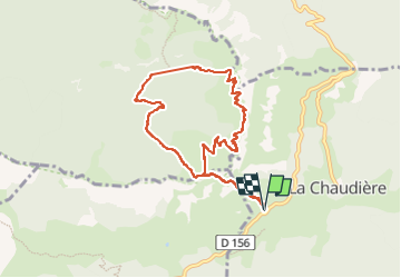

Length
9.3 km

Max alt
1565 m

Uphill gradient
741 m
Km-Effort
19.1 km

Min alt
1043 m

Downhill gradient
740 m
Boucle
Yes
Creation date :
2025-05-27 08:08:15.022
Updated on :
2025-05-27 13:43:02.36
3h21
Difficulty : Very difficult

FREE GPS app for hiking
 SityTrail
IGN / Geographical institutes
SityTrail Plus
The world is yours!
About
Trail Walking of 9.3 km to be discovered at Auvergne-Rhône-Alpes, Drôme, La Chaudière. This trail is proposed by gdela.
Positioning
Country:
France
Region :
Auvergne-Rhône-Alpes
Department/Province :
Drôme
Municipality :
La Chaudière
Location:
Unknown
Start:(Dec)
Start:(UTM)
674877 ; 4944162 (31T) N.
Comments